About This Worksheet
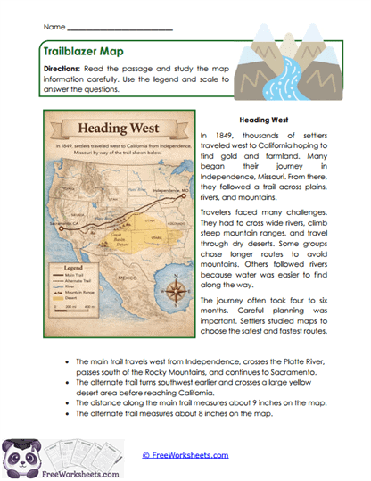
This worksheet is a visual elements activity that focuses on using maps, legends, and scale to understand geographic information. It is designed for Grade 5 students who are learning how to read and interpret maps alongside written text. Students explore how routes, distances, and landmarks are represented visually and supported by a passage. For example, a trail’s length on the map becomes more meaningful when students use the scale to estimate real distance.
Curriculum and Grade Alignment
This worksheet supports Grade 5 students in integrating geographic visuals with informational reading. It focuses on map-reading skills such as interpreting legends, scale, and routes. It aligns with Common Core RI.5.7, which emphasizes using multiple sources of information. It also connects to TEKS 5.9F and social studies standards related to geography and map skills.
Student Tasks
On this worksheet, students will read a passage about westward travel and study a detailed map. They use the legend and scale to answer questions about distance and routes. Students compare the main trail and an alternate path. They explain how the map helps them better understand the journey described in the text.
Common Challenges and Misconceptions
Students may overlook the legend or not fully understand how to use the scale. Others might focus only on the text and ignore the map. Some may struggle to connect map details back to the passage. Teachers can model how to read each part of the map step by step.
Implementation Guidance
Teachers can use this worksheet during social studies or geography lessons. It works well as a guided activity where students explore maps together. Parents can use it at home to support map-reading skills. It also helps students build real-world navigation and interpretation skills.
Details and Features
The worksheet includes a detailed map with labeled routes, a legend, and a scale. It provides a supporting passage and targeted questions. The layout is engaging and easy to print. It supports both reading comprehension and geographic reasoning.
Curriculum Overlap
Reading maps supports social studies learning and real-world navigation skills. This skill strengthens math understanding through scale and measurement. It also improves comprehension of informational texts that include visuals.
- Supports geography and social studies skills
- Strengthens measurement and scale understanding
- Improves real-world navigation skills
- Builds visual-text integration skills